BACKGROUND / VANCOUVER : AN ARTIST'S VIEW OF THE CITY, OCTOBER 30, 1972
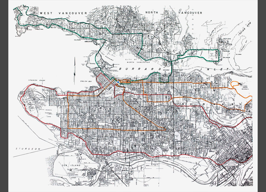
Using a map of the city, they plotted three routes which began and ended at Victory Square. Each route passed through the city core and out to the perimeters in far-flung overlapping loops.
DESCRIPTION
The routes in brief, starting at (A1)top left with Gerry Gilbert's (in green), are as follows: Victory Square (blue dot), Georgia, over the Lion's Gate Bridge and along the Lower Levels Highway to Horseshoe Bay. Then back along the Upper Levels Highway to Deep Cove, over the Second Narrows Bridge, past the PNE, down Renfrew to Commissioner and Centennial Pier and so by Hastings back to "Victory" where it is now night. (F10).
"Victory" in daylight (F11) is the photo immediately to the right as Glenn Lewis and Taki Bluesinger (in orange) start there run. They head to Simon Fraser University by way of Hastings and Sperling, then return on the Lougheed Highway. They pass through Gastown, drive south on Theater Row and across the Granville Bridge.
After their surprise visit to the Ministry of Truth, they circle back under the Granville Bridge, proceed along Fourth, South on Dunbar, east along Forty-first and back by Kingsway and the Georgia Viaduct. They photograph each other at dusk standing pensively in front of the Cenotaph (K15 and 16) like a signature.
(K17) is yet another view of the Cenotaph as Michael de Courcy (in red) sets out (all photos were taken on the same day.) His route leads up Cambie to Robson, then Denman to Beach, over the Burrard Bridge and along Point Grey Road, past Spanish Banks to UBC. then follows S.W. Marine Drive to New Westminster, which is his turnabout point.
He comes back to town along Columbia and the 401, takes Terminal to Main, Main to Second, over the Cambie Bridge to Beatty and so arrives once more at the memorial.
City By Mural - Joan Lowndes, Vancouver Sun, 1974